
Salt River Fields at Talking Stick
Location
The Salt River Pima-Maricopa Indian Community is uniquely positioned in one of the most desirable geographic regions of the entire metropolitan Phoenix area.
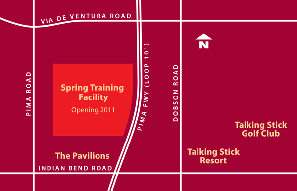 The 140-acre Spring Training Facility site will feature vast panoramic views of some of central Arizona’s most iconic mountain ranges and will also be located near the award winning Talking Stick Golf Club, the Pavilions retail center, Talking Stick Resort and Casino Arizona at Talking Stick.
Access/Transportation
The Salt River Pima-Maricopa Indian Community is served by major freeways, Interstate 10, Interstate 17, and the Red Mountain Freeway Loop 202 and the Pima Freeway–Loop 101, both of which border the Community.
The Loop 101 provides nine interchanges along a nine-mile stretch on the Community’s western boundary while the Red-Mountain Freeway–Loop 202 follows the southern boundary. Highway 87–Beeline crosses the Community from south to east.
The Community is also well positioned for air service. It is within 15 minutes of Phoenix Sky Harbor International Airport and less than 10 minutes from Scottsdale Airpark with its executive terminal and air service. Over 20 domestic and international airlines contribute to the nearly 1,500 daily flights that carry 150,000 passengers to and from the airport’s three terminals.
A light rail system opened in 2008 and serves the valley’s major cities including Phoenix, Tempe and Mesa.
Mountain Views
Camelback Mountain, to the west, is well known as an image of the Valley of the Sun. To the north rise the McDowell Mountains with miles of hiking and biking trails available for the adventurous. To the east is the majestic Red Mountain, a symbol for the Salt River Pima-Maricopa Indian Community. Beyond Red Mountain rise the sacred Four Peaks and the Superstition Mountains which legend says hold the secret of the Lost Dutchman Gold Mine.